March 23, 2025
University of Missouri engineering researchers are using advanced technology to help make our roads safer by better understanding how pedestrians, cyclists and vehicles interact.
March 24, 2025
Contact: Eric Stann, StannE@missouri.edu
University of Missouri researchers are using advanced technology to enhance the safety of the nation’s roads. This approach, focused on the most vulnerable road users — pedestrians and cyclists — could be used to help improve driver awareness, reduce accidents and better understand behavior in work zones.
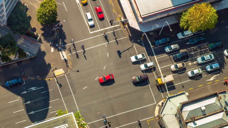
In a recent study, a team led by Associate Professor Yaw Adu-Gyamfi and graduate student Linlin Zhang at Mizzou’s College of Engineering created a new method to understand how pedestrians, cyclists and vehicles interact, especially at traffic signals. This innovative approach, using a combination of light detection and ranging (lidar) and artificial intelligence (AI), aims to addresses key issues in transportation safety and mobility.
Lidar uses a camera and a system of lasers to create a 3D view of objects, enabling experts to measure the distances and speeds of different objects, such as bicycles, cars and people.
“By having a better understanding of how pedestrians and cyclists interact with each other on the roads, this study will help us design advanced systems that will allow vehicles to better understand and avoid other road users. This is important especially as autonomous vehicles become more common,” Adu-Gyamfi said.
The information provided helps address a lack of available industry data on the interactions between cyclists, pedestrians and vehicles at traffic signals.
Real-world uses
This technology can help spot close calls between cars and pedestrians, allowing experts to better understand how to prevent accidents. As it becomes more widely available, it could track how people and cars approach intersections and share that data with vehicles to improve safety.
“This approach would require working with car manufacturers to build the technology into vehicles,” Adu-Gyamfi said. “In fact, some cars already connect with traffic systems using networks like cellular vehicle-to-everything (C-V2X).”
The data collected by this system could be used in other ways to improve transportation such as helping experts decide how long pedestrians need a green light to cross safely. It could also track cars entering work zones, catching speeding or distracted drivers. Plus, it can spot pavement problems, such as the depth of potholes.
How it works
For this project, researchers set up a joint camera and lidar system at an intersection to monitor traffic flow. Instead of the traditional approach that requires using two lidar units, they successfully optimized the technology to work with just one unit. Also, by applying a method called point cloud completion, they were able to improve the visibility of pedestrians and other objects over existing methods.
“Instead of retraining a machine learning model to detect objects, we used a pre-trained one and created a new algorithm to estimate an object’s height and width,” Adu-Gyamfi said. “This helped us classify objects, such as buses, pedestrians and cyclists, more accurately than other AI models designed for the same task.”
Before this technology can be widely used on roads and highways, researchers will need to address challenges with data processing, power supply stability and weather conditions.
The study, “Three-Dimensional Object Detection and High-Resolution Traffic Parameter Extraction Using Low-Resolution LiDAR Data,” was published in the Journal of Transportation Engineering. Co-authors are Xiang Yu at Mizzou and Armstrong Aboah at North Dakota State University.
This story was originally published by Show Me Mizzou here. Learn more about civil engineering research at Mizzou.