April 10, 2022
A Mizzou Engineering team has developed a web resource that allows users to sort and view health, socioeconomic, accessibility and population data by county.
The Geospatial Analytical Research Knowledgebase (GeoARK) was supported by a RAPID grant from the National Science Foundation. Leading the effort is Chi-Ren Shyu, Paul K. and Dianne Shumaker Professor of Electrical Engineering and Computer Science and director of the MU Institute for Data Science and Informatics.
While COVID-19 brought urgency for the implementation of this work, the project has wider applications and allowed researchers to demonstrate how they can turn massive amounts of geospatial data — or information based on location — into accessible information within a single user-friendly interface.
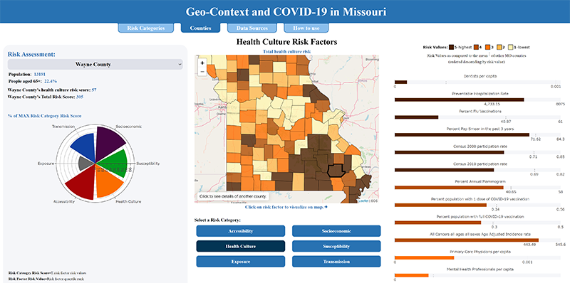
Not only does GeoARK provide maps showing where COVID-19 is still a threat in Missouri, it also provides context by showing both compiled and individual potential risk factors.
Visitors to the site can select a county and find the population density per square mile, households with those 65 and older, cancer rates, poverty rates, air quality and dozens of other parameters from any given area. It’s so specific, you can even see how many people in a county work in meat processing plants, the percentage of people who carpool to work and how many people live in nursing homes or residence halls.
“For the first time, we can really address context, and by addressing context, I think we’ll be better able to understand and position society, if you will, with regards to disparity, inequities and other big driving questions,” said Tim Haithcoat, Deputy Director of the Center for Geospatial Intelligence at MU. “It’s all about different data sets existing in the same space. Ultimately it helps answer complex questions and provides new information that researchers are asking for, policymakers are asking for, and citizens are demanding.”
While the funding was specifically for Missouri, Shyu and Haithcoat have collected the same type of data from the U.S. Census, national databases and other public sources. They then associated that data with points located every tenth of a mile in every county in all 50 states.
“To put that into context, it would historically have taken a researcher an entire career to pull together that amount of information,” Shyu said. “To think of it another way, the data would occupy 162 million rows across more than 5,500 columns on an Excel spreadsheet. It is now integrated within a Big Data ecosystem.”
And the information can be used to answer questions beyond COVID-19, Shyu stressed.
Knowing information about a population based on where they live is critical to understanding other issues. For instance, in a separate study, Shyu looked at how income disparities in a community correlate with health problems.
Geospatial data can also help states better respond to other disasters by knowing more about the people in the area who are impacted.
“It’s critically important to understand location as the starting point for studying many things, not only in health care, but also social sciences and other areas,” Shyu said. “GeoARK can help answer many questions and help researchers and policymakers make decisions based on data. Our system is unique in that it links all of this information together for all stakeholders. They can answer research questions or policy questions that previously could not be answered.”
“GeoARK has already done all of the heavy contextual lifting,” Haithcoat added. “Now anyone can leverage everything we put together and have geospatial analytics and qualification to apply to their questions of interest.”
Shyu and Haithcoat, along with co-authors Danlu Liu and Tiffany Young, outlined their geospatial big data ecosystem in a paper just published in the journal JMIR Medical Informatics.
Funding sources: NSF IIS-2027891 and NIH 5T32LM012410
Work with researchers taking geospatial data science to new heights. Become a Mizzou Engineer!